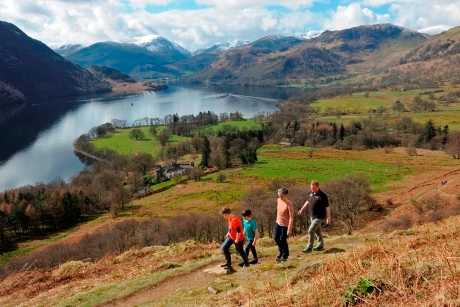
Walking groups visiting the Lake District can take advantage of a newly created 20-mile walking route called the Ullswater Way.
This is the first circular route that goes fully around Ullswater Lake, and finally gives visitors the chance to map the entire circumference of the second largest lake in the Lake District.
The Ullswater Way crosses sections of open fell and farm land, offering visitors a panorama of the lakes and countryside.
The route also includes a new section of footpath near Maiden Castle, once the site of an Iron Age hill fort. From here, groups will be able to enjoy views of the Ullswater Valley, the Pennines to the east, and Blencathra to the west.
Walkers can enjoy improved access around the lake, including a new 2.5-kilometre public right of way, and the installation of new way markers, fingerposts and gates to make it easier for people to navigate around the lake.
Groups choosing to walk the new route can take advantage of a new Ullswater Way leaflet with a map that shows the length and level of the walks available in the area.
The Ullswater Way means long distance walkers can now walk round the full 20-mile route, while those who want to explore at a more leisurely pace can do so by enjoying one of the region’s many attractions like a trip on the historic Ullswater Steamers.
More about the creation of the Ullswater Way
The new route has been created following the floods in December 2015 in order to boost tourism in the area.
It’s been shaped by a partnership between local people and the Lake District National Park, the National Trust, the Ullswater Association, Eden District Council, Ullswater Steamers, and See More Cumbria, with additional funding from the Cumbria Waste Management Environment Trust.
You can find out more about the making of the new Ullswater Way by watching the video below:
For further information visit www.Ullswater.com.
(Photo credit: Val Corbett).


